- English
- Francais


Converting British Trench Map Coordinates
posted by warren
on Tue, 03/05/2013 - 21:56

The First World War took many by surprise. The speed of the German advance and the expectation of a short war meant that no large scale maps of mainland Europe were available. Another problem with war preparation in that era is that mapping another country was a certain sign of impending invasion, to the point that official surveyors would sometimes get arrested by the local authorities for spying.
As the Central Powers moved into Belgium, the original printing plates of the "Old Belgium Grid" were moved from Antwerp to London ahead of the invasion. It was decided to use the Belgium plates as a starting point for new maps of the Western front . The 1:40,000 numbered grid covered only Belgium (again - you only get to map your own country or else your neighbors get twitchy) but it was a start from which more maps could be created.
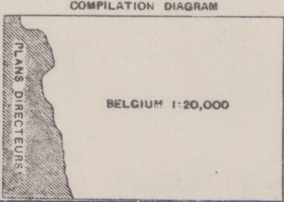 The Belgium state maps sheets where built on a numbered grid with the origin at Brussels. The grid was extended from the original sheets with the same sheet lines as a metric distance from the origin and extending the grid number with letters (57a, 57b, etc...). While the original plates covered slightly outside of Belgium, the only immediate source of mapping data was the Plan Directeur, large scale maps used to lay artillery fire from French forts. British field survey troops were sent out to fill-in the blanks wherever needed. A compilation diagram is located on the edge of each sheet which records the source of the data used to create the sheet. The one on the right hand side is from Sheet 37, on the Belgium border with France. The accuracy of the maps varies widely with the sources used: the original Belgium Sheets where directly copied at 1:40,000, while the Plan Directeur were scaled up from 1:100,000 sheets. The objective for a British Survey Team would be to have the accuracy down to about 20 yards, but even better maps would eventually be produced by projecting aerial photographs and tracing contours. In the final analysis, the accuracy was not as important as having everyone use the same grid system over the same issue of maps.
Because longitude and latitude were not really workable for tactical military communications, a grid was superimposed over the 1:40,000 maps. For reasons that are lost in the annals of inter-branch miscommunications the map grid was itself based on yards instead of the maps sheet lines that were in meters. Of course, meters and yards are slightly different and thus the grid does not align with the distance from the origin in meters, making the determination of the modern day longitude and latitude painful. Because the grid spills over the edges of the map, it is possible to have two sets of Trench Map coordinates refer to the same place. This no doubt sent more than one officer cursing trying to find locations at the edges of his map.
The actual projection of the maps was the Belgian (and in some French maps) Bonne projection. The Ellipsoid, or the specific size and shape of the planet, used was the Delambre one from 1810. The origin at Brussels is a point of contention; different publications report different locations. Another reports the origin as being the old Brussels observatory which unfortunately moved several times. Both the position recorded by [1] as 50°25'0.0006", 4°22'12.6978" and [2] as 51°10'06.895", 4°22'05.89" both of which are a few kilometer off. After a bit of help from the Nationaal Geografisch Instituut and the triangulation from [3], the actual origin of the map as 50°24', 4°22'5.89", which give results that are reasonable.
Keep in mind that the actual accuracy of a specific map series varies. The expected accuracy of the work done by a British survey company was 20 yards. However, the initial maps made from French and Belgian sources were not always completely accurate and pieces of the maps were gradually re-surveyed over time. Furthermore, the minimum grid increment was 50 yards or 5 yards if the map reader had a romer that wasn't bent. The result is that the accuracy of trench coordinates can vary by as much as 100 yards - as with all things, your mileage will vary.
After some amount of work I've created an API to convert trench map coordinates to and from longitude and latitude. There is a web page here that you can use to find coordinates on a modern map.
Over time I will use this to link-up the trench coordinates within the war diaries and map collections to the recently announced Open Historical Map website. This website is an offshoot of the Open Street Map that is dedicated to mapping historical features and changes to them over time.
References
- , “The Kingdom of Belgium”, PHOTOGRAMMETRIC ENGINEERING & REMOTE SENSING, pp. 956-957, 1998.
- , Report on survey on the Western Front 1914-1918. London: His Majesty's Stationery Office, 1920, p. 200.
- , Triangulation du Royaume de Belgique. Cnophs, 1867.
English
- Log in to post comments