Languages

lod

Vimy Ridge Day WWI Project Roundup

Apr
09

On April 9th, 1917 the Canadian Corps attacked the German positions on Vimy Ridge. In honour of the 101st anniversary, here is a short roundup of WW1 projects and efforts that are ongoing. 

  1. Bert V. de Bruijn of wikiwar.net fame is still working on making a ridiculously detailed map of the battle of Vimy Ridge and has setup a task manager for Open Historical Map to digitize the trench maps from the McMaster Trench Map Collection
  2. Erik Hellstedt in Belgium is working on animating the First World War using Commonwealth War Graves Commission data. 
  3. Heather Pretty from Memorial University has been working on generating more linked open data for the Royal Newfoundland Regiment during the war, including personnel data.
  4. Stan Hebben and Dries Chaerle at the In Flanders Fields Museum in Belgium are running a project "The Names List"  to collect information about victims – both military and civilian – which died in Belgium during the course of (and due to) the First World War
  5. Warren Lewington has been working on artillery logistics on the Western Front (2 Minute Video here, PDF Project Description).
  6. Bill Frost has built an awesome Trench Mapping application for tracking events on the Western front. 


Aware of another project? Please reach out to @muninn_project!

English
Posted By warren read more

CanLink: Linked Open Theses

Sep
29

CanaLien : un projet de données liées pour les thèses Canadiennes - CanLink : a linked data project for Canadian theses is now online!

CanLink is a collection of thesis data from collaborating institutions part of the Canadian Linked Data Initiative. It features over 5,000 theses from participating Canadian universities[1] on a broad range of topics, from "post-humans" to "mechano-electric feedback" with new theses being added on an ongoing basis. The project is an initiative of the Digital Projects committee of the Canadian Linked Data Initiative with the development work done by Sharon Farnel, Rob Warren and Maharsh Patel[2].

The data set is described in void / dcat format and is also registered in the Data Hub. The virtual machine is provided by West Grid and the domain name is provided by the University of Alberta.

English
Posted By warren read more

Linked Open Data: We Need Cool Tools

Sep
05

A disturbing trend emerged during both LODLAM 2017 in Venice, Italy and Digital Humanities 2017 in Montreal, Canada concerning Linked Open Data and the semantic web in general. Both conferences were chalk-full of projects that were either creating data or thinking of publishing their data as Linked Open Data, but very few projects dealt with the consumption of the data. When the topic of consuming LOD is discussed, it is in the context of faceted search or schema.org style discovery. This is problematic because we are not leveraging the linkages of the data and the work done within the project ontologies. And... who really wants to look at triples? The Linked Open Data tools available so far (Pelagios CommonsTrench Map Converter) tend to be highly integrated with the data of the organization that created it, if we are to move on with this technology we need tools that apply to multiple datasets.

Scrambling for sessions at LODLAM 2017The LODLAM 2017 session Cool tools was well attended by over 30 people crowding around the tables in the Salone Degli Arazzi about cool tools to consume LOD. Oddly, most of the tools discussed were still of the backend or engineering variety. With production getting so much attention, the lack of thought about consumption is concerning: What do we expect end-users and scholars to do with this data? When asked what tools they would like to see, the session members still talked about workflow toolchains and backend facing processes. This isn't unexpected as LAM practitioners worry about their day to day responsibilities first and foremost. Enrichment and creating linkages were similarly popular topics as people wanted to cross-link their datasets on a larger scale than is possible with manual methods. For all of the work entailed, it is all primarily a straight-forward engineering problem. 

English
Posted By warren read more

The Geometries of Vimy Ridge, 100 years ago

Apr
07

The Battle of Vimy Ridge began 100 years ago on April 9th through 12th, 1917. It holds importance in the Canadian consciousness in that this was the first time that the Canadian Corps fought as a single unit on the Western Front with the 1st, 2nd, 3rd and 4th Division deployed side-by-side1. With a lot of patient geo-referencing work and a joint efforts between Muninn, the Canadian Expeditionary Force Study Group and Wikiwar, a number of the units locations, place names and trenches have been extracted. The simplest way at the moment to visualize the locations is through the Open Historical Map which is an OSM-like website that records historical mapping data and can export the raw geometries for further use. 

At the time of the Battle of Vimy Ridge, the Headquarters of the Canadian Corps were located near Camblain-l'Abbé  (Painted by David B. Milne in 1917). The 1st Canadian Division Headquarters was located in Écoivres near the banks of the La Scarpe river. It's troops were the southernmost deployed with the 17th Corps at their right and the 2nd Canadian Division at their left. The 2nd Canadian Division Headquarters was in a farmer's field near route D58 (There is a google street view pictures of the houses and farms at that current location). The 3rd Canadian Division was next to the left and the 3rd Canadian Division Headquarters was located in Villers-au-Bois. The 4th Division was the northernmost with its flank against the 1st Corps and the 4th Division Headquarters located in a farmer's field near route D65.

How accurate is this information?

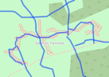
A survey section during the war would be expected to triangulate a feature within 20 yards while out in the field. In actuality areas of high activity were well surveyed and the accuracy of a trench map is often within 5 yards for important features. Since we used hand tracing to extract the trenches some inaccuracy is to be expected. One can do much better by creating a line finding algorithm that traces the trench based on colour separation and that will be the topic of future work. The figure to the right is an overlay of the German trenches extracted from a trench map over the Open Street Map's rendering of the current preserve trenches at the Vimy Ridge Memorial. The alignment is not perfect, but sufficient for way-finding purposes.

The location of the Headquarters and the area of operations of the different Divisions, Brigades and Battalions are derived from an aggregate map that was reprojected based on landmarks contained within the current landscape and those within other georeferenced trench maps of the period. The original map was not to scale and large (a 100 meters of so) errors in location can be expected. Of course, features such as a Battalion's area of operations are very large and even a Brigade headquarters involves multiple tents and/or buildings. The map locations on the original source map were simple icons which created their own spatial inaccuracies and one should expect large errors in the actual location. Whenever possible, you should use these features as general areas and not consider their centroid as the ground truth.

This represents the best information currently available and the geometries will improve over time as more information is unearthed. All of these geometries are available from the Open Historical Map's export function which works with all of the tools that were designed for the Open Street Map. 

Where did you get this information?

The trenches and trench name information were extracted from maps M_81_000287 and M_89_000382 in the Imperial War Museum's archive.  The parameters for the reprojection are described in [1], [2] and this ontology document. Tracing was done manually and exported to both shape files and RDF before being imported to the Open Historical Map. 

The location of the headquarters and units during the onset of the battle are derived from the aggregate "map 7" from the Official History of the Canadian Army in the First World War: Canadian Expeditionary Force, 1914-1919 ([3]). The original book was scrubbed for image quality and reprocessed by the good folks at the Canadian Expeditionary Force Study Group before its map was reprojected and bounding areas created before being exported to the Open Historical map.

1. The 5th Canadian Division was not fully formed at the time and it's units were absorbed by the other Divisions.


English
Posted By warren read more

The Business Value of Linked Open Data

Apr
24

Note: The following is a synopsis of comments I made to the Publishing and Managing Linked Open Data in Cultural Heritage Institutions session at Museums on the Web 2015. I'm posting them after a follow up conversation with Cristina Pattuelli of the Linked Jazz Project.

What is the business value of Linked Open Data? What is the business case that drives you to support / invest / develop into yet-another-platform and what will it do for your business/library/museum/archive/store-front? Anecdotal, academic and one-off examples aside, why should you care?

A quick answer to these questions In three parts: because a) it promotes and facilitates citation (eg: Marketing), b) creates cost externalization opportunities  (eg: Get other people to do your work) and c) it leverages the idiosyncrasies of your business (eg: Your unique selling proposition).

English
Posted By warren read more

Reusing LOD Vocabularies: It's not all it's cracked up to be.

Mar
24

"Re-use data, re-use vocabularies", this has been the battle cry for Linked Open Data and Semantic Web enthusiasts since day one. Formally, the W3C Government Linked Data Working Group has published a Working Group Note on the matter where they state that "Standardized vocabularies should be reused as much as possible to facilitate inclusion and expansion of the Web of data". What seems to be a reasonable point of vue has been pushed a little bit too strongly of late.

English
Posted By warren read more

Great Britain declares War on the German Empire

Aug
04

On August 4, 1914, Great Britain declared war on the German Empire for, among a long list of complex reasons, violating Belgian Neutrality as they attempted to invade France through Belgium. While the cabinet declared war on the German empire and not the King, this was primarily a constitutional delicacy. It was really the British Empire declaring war on the German Empire and that the Dominions and the British Indian Empire would support Great Britain directly was no more surprising than Austro-Hungary supporting Germany.

English
Posted By warren read more

Linked Open Data for Ultra Realistic Simulations

May
05

One of the uncomfortable questions that is often repeated with projects generating linked open data is "So, you've created a database. Now what?". You've created the datasets, published them in linked open data and created useful API's, SPARQL endpoints and maybe even a nice html layout for the data. But how do you actually use the data and does it actually ever get used?  

English
Posted By warren read more
Subscribe to RSS - lod